A Digital Twin-Driven Optimization of Urban Blue-Green Networks for Healthy Cities: A Multi-Scale Accessibility and Visibility Analysis Framework
Keywords:
Digital Twin; Healthy City; Blue-Green Network; Spatial Accessibility; Spatial Visibility; Multi-Scale AnalysisAbstract
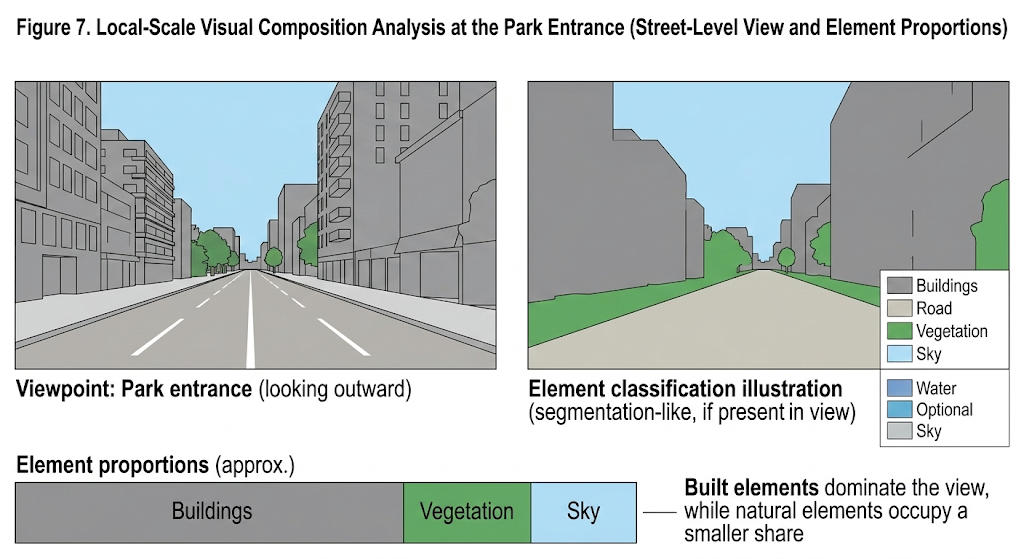
As cities around the world continue to expand, creating healthier urban environments has become a central challenge for sustainable development. Blue-green networks—systems of interconnected parks, rivers, wetlands, and green corridors—serve as essential ecological infrastructure in cities and play a critical role in improving both the physical and mental well-being of residents. Despite their importance, current planning and design approaches for these networks often lack detailed and systematic methods for evaluation and optimization, which limits their ability to fully deliver health benefits. The rise of digital twin technology offers a powerful new way to tackle this complex challenge. This study proposes a multi-scale optimization framework for healthy urban blue-green networks driven by digital twins. The framework integrates several advanced analytical tools: the spatial data processing power of Geographic Information Systems (GIS), the urban morphology analysis capabilities of Space Syntax, and computer vision techniques that capture how people perceive the built environment. Using a representative city as a case study, the research constructs a high-fidelity urban digital twin model by combining multiple sources of heterogeneous data, including remote sensing imagery, built environment information, and population distribution datasets. Based on this digital model, the study performs systematic simulations and optimization analyses of blue-green network accessibility and visibility across three spatial scales: regional, district, and local. The findings demonstrate that the proposed framework can effectively detect weak connections and service gaps within existing blue-green network layouts. It can also precisely evaluate how different spatial intervention strategies—such as adding new entrances to green spaces, improving pedestrian pathways, or regulating building heights—may influence the health benefits experienced by residents. By simulating these interventions, the system can generate spatial optimization strategies that balance both equity and efficiency in urban service provision. Overall, this research provides planners and decision-makers with a quantifiable, interactive, and iterative tool for designing healthier cities. At the same time, it presents a practical example of how digital twin technology can be deeply applied in the field of urban ecological environments, supporting a shift toward more scientific, data-driven, and refined approaches to urban planning and design.